Why Melbourne Keeps Building Around Railway Stations
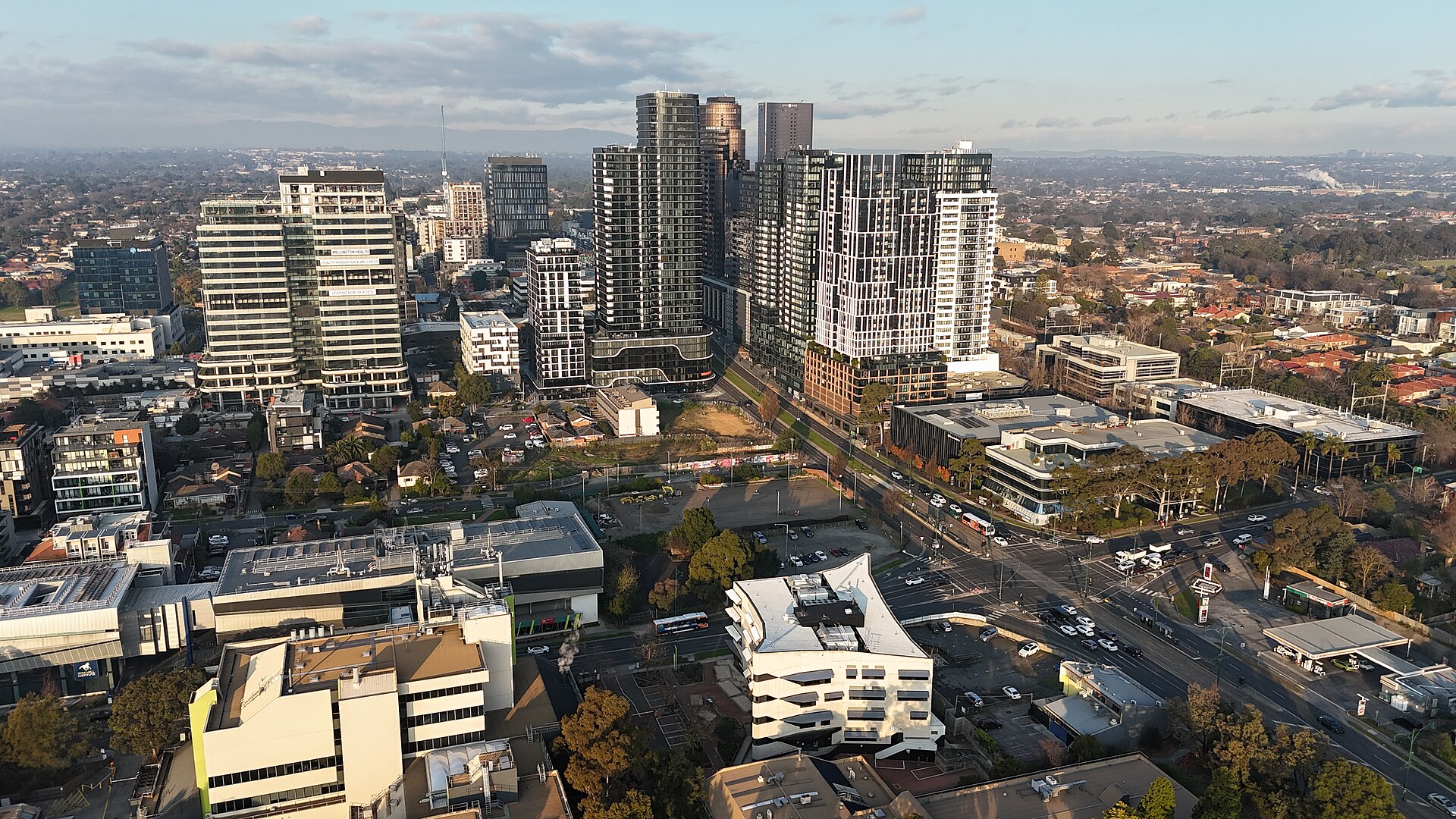
The Victorian government has finalised planning controls for 60 activity centres on train and tram lines, intended to enable more than 300,000 homes across the program. The controls allow taller buildings at each centre’s core and low-rise apartments and townhouses within walking distance. The idea is presented as a response to a housing shortage. It is also something older: a return to the pattern of growth that produced Melbourne’s suburbs in the first place. The photograph is Box Hill, where a cluster of high-rise towers stands next to the station and a tram terminus.
The railways built the suburbs
Australia’s first steam railway ran in Melbourne, on 12 September 1854, between Flinders Street and Sandridge. The early lines were private companies, and several were built by land speculators with short-term motives. For two decades the suburban network barely grew. That changed in the early 1880s, when the government-owned Victorian Railways took over the private lines and, under a chief commissioner who believed any line within nine miles of the city would pay, more than doubled the network’s length.
The result was a city organised around its stations. Melbourne’s railways were built on a radial pattern, and development followed: clusters of houses and businesses formed around individual stations, a pattern still visible in the pre-1950s housing within walking distance of them. Railways were an important factor in the land boom of the late 1880s, and the Railway Construction Act 1884, known as the Octopus Act, authorised 66 separate lines. Estates took the word railway into their names, sometimes with little regard for the distance to the nearest station. By 1890, Melbourne was among the most suburbanised cities in the world.
The shopping strips came from the same logic. Close to stations, especially where tram routes met them, well-defined strips were built; the trams themselves shaped the long retail streets such as Chapel Street and Sydney Road. Melbourne was also the first Australian city to electrify its suburban network, with the first scheduled electric service on 28 May 1919 between Essendon and Sandringham, and the conversion complete by 1923. The suburbs and their shopping and entertainment facilities were laid out so people could move around them on foot or by public transport.
The car filled in the gaps
After the Second World War, the motor car took over as the main shaper of growth. Cars and trucks freed households and industry from the need to locate near a station, and the areas between the public transport routes filled in with houses and workplaces. A 1969 plan for 491 kilometres of freeways was dropped after protests, and Melbourne kept its trams, but the city still spread outward at low density along roads as much as rails.
That postwar settlement is now the problem the current policy is aimed at. Melbourne remains a low-density city by world standards, with the car dependence and high infrastructure costs that come with it. At the end of the Second World War, the city still had large areas of potential suburban land within walking distance of electric trains. In 2026 it has large areas of established suburb within walking distance of them, which is a different asset, and the one the state has decided to use.
Why the policy came back
The arithmetic behind the program is on the department’s own page: metropolitan Melbourne is expected to need around 1.8 million homes by 2051, and the state’s position is that growth should go where transport, jobs and services already exist. The Train and Tram Zone Activity Centres Program sits under Plan for Victoria, the current state-wide strategy, which replaced Plan Melbourne 2017–2050, the strategy that framed growth around 20-minute neighbourhoods. The department says the program aims to align future housing with existing public transport and infrastructure, and that the 60 centres were chosen on market readiness, transport capacity, access to jobs and services, and environmental constraints.
What the controls actually do is narrower than the announcement language suggests. Each centre’s plan sets heights for a core, with low-rise apartments and townhouses in the surrounding catchment, and introduces provisions intended to streamline permit applications. The state is not acquiring land, and existing heritage protections continue to apply. The program-wide figure of more than 300,000 homes is capacity the controls are intended to encourage. It is not a construction program, and it is not dwellings with a permit.
What it looks like on the ground
West Footscray shows the pattern at suburb scale. Amendment GC270, in operation since 31 March 2026, sets discretionary core height limits of 21, 27, and 34 metres depending on the area of the schedule map, with lower heights stepping down through a roughly 800-metre catchment, and a six-storey limit on the north side of Barkly Street so the street keeps its sun. The detail is in our earlier story. A permitted 34 metres is a ceiling an applicant can build under or seek to exceed. It is not a tower, and a tower is not a suburb.
Box Hill shows what decades of station-focused growth produce. Its towers sit within a short walk of the station and the route 109 terminus, under planning rules that predate the current program. Whether the 60 new centres converge on that form, or on something less tall and less concentrated, will be decided permit by permit over decades, not by the maps published this year.
The dependence on the market
The controls supply permission; the buildings come from developers. The same constraint appears in the Suburban Rail Loop audit, where the Auditor-General found the precinct strategy’s expected housing and employment benefits depend on private investors who already face challenging market conditions. An activity-centre control and an SRL precinct plan are different instruments, but the risk is the same: enabled capacity is not delivered capacity.
The program’s design accepts part of that risk. The department’s page notes the provisions are meant to make applications faster and easier, which is a supply-side lever the state controls. What it does not control, and does not fund through this program, is the infrastructure and services that follow the residents.
What to watch
- the first significant permit applications under the new core controls, particularly where an applicant seeks height above the standard;
- whether infrastructure commitments, funded and scheduled, accompany the centres as their catchments grow;
- any further tranche of centres beyond the 60 already finalised.
References
- Train and Tram Zone Activity Centres Program, Department of Transport and Planning. Plans finalised for 60 centres, more than 300,000 homes as the program-wide figure, around 1.8 million homes needed in metropolitan Melbourne by 2051, no compulsory acquisition of land, and heritage protections continuing to apply.
- More homes through activity centres, Department of Transport and Planning, page last updated 30 September 2026. Taller buildings at each core, low-rise apartments and townhouses within walking distance, and the selection criteria: market readiness, transport capacity, access to jobs and services, and environmental constraints.
- About the program, Department of Transport and Planning. The program’s aim of aligning future housing with existing infrastructure and transport networks.
- Plan for Victoria, Department of Transport and Planning. The current state-wide growth strategy and its five pillars, including housing for all Victorians.
- Plan Melbourne 2017–2050, Department of Transport and Planning. The previous metropolitan strategy and its 20-minute neighbourhoods framing; the page records that Plan Melbourne has been superseded by Plan for Victoria.
- Railways, eMelbourne, The Encyclopedia of Melbourne Online, School of Historical and Philosophical Studies, University of Melbourne. The 1854 Flinders Street to Sandridge line, the government takeover and 1880s expansion, the radial pattern and station clusters, the Railway Construction Act 1884, and the electrification dates.
- City Growth, eMelbourne, The Encyclopedia of Melbourne Online, School of Historical and Philosophical Studies, University of Melbourne. Boom-era suburbs along the rail lines, shopping strips near stations and tram routes, and postwar growth between the routes.
- Suburbs and Suburbanisation, eMelbourne, The Encyclopedia of Melbourne Online, School of Historical and Philosophical Studies, University of Melbourne. Railway-led suburban growth in the 1880s and Melbourne’s standing among suburbanised cities by 1890.
- Amendment GC270, Maribyrnong Planning Scheme, Department of Transport and Planning, in operation 31 March 2026. The West Footscray core height limits and catchment controls.
- Delivering the Suburban Rail Loop, Victorian Auditor-General’s Office, tabled 26 August 2026. The finding that SRL precinct benefits and value capture revenue depend on private investors facing challenging market conditions.
- Photograph: Aerial view of Box Hill CBD looking east from Kingsley Gardens in Mont Albert, 4 July 2024, Takerlamar, CC BY-SA 2.0, via Wikimedia Commons.