West Footscray
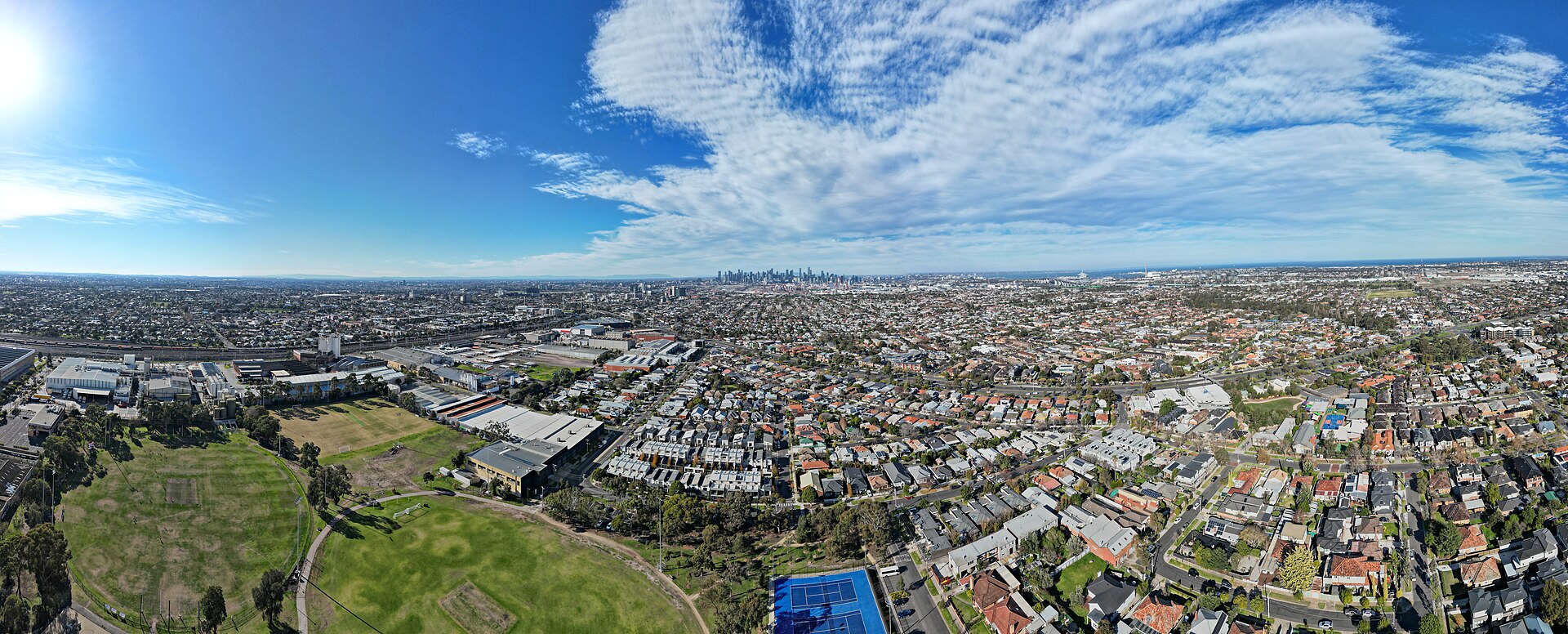
West Footscray is an inner-west suburb in Maribyrnong City Council, immediately west of Footscray. It developed as that suburb’s industrial edge: basalt quarries, then factories along the railway, including the Olympic tyre plant on Cross Street. The Sunbury line still runs through it, and the station sits in the activity-centre core. The photograph is an aerial view in June 2025, looking east toward the city.
At a glance
Reviewed 2026-11-01.
Council: Maribyrnong City Council
The council is Maribyrnong. The population figures are in the census section below, and they are for the suburb.
What is changing
The largest current work is Melbourne Airport Rail stage 1, the corridor from here to Albion. That stage does not add a train to the airport. How that corridor sits against growth further west is the west is changing faster than the old infrastructure.
Location and boundaries
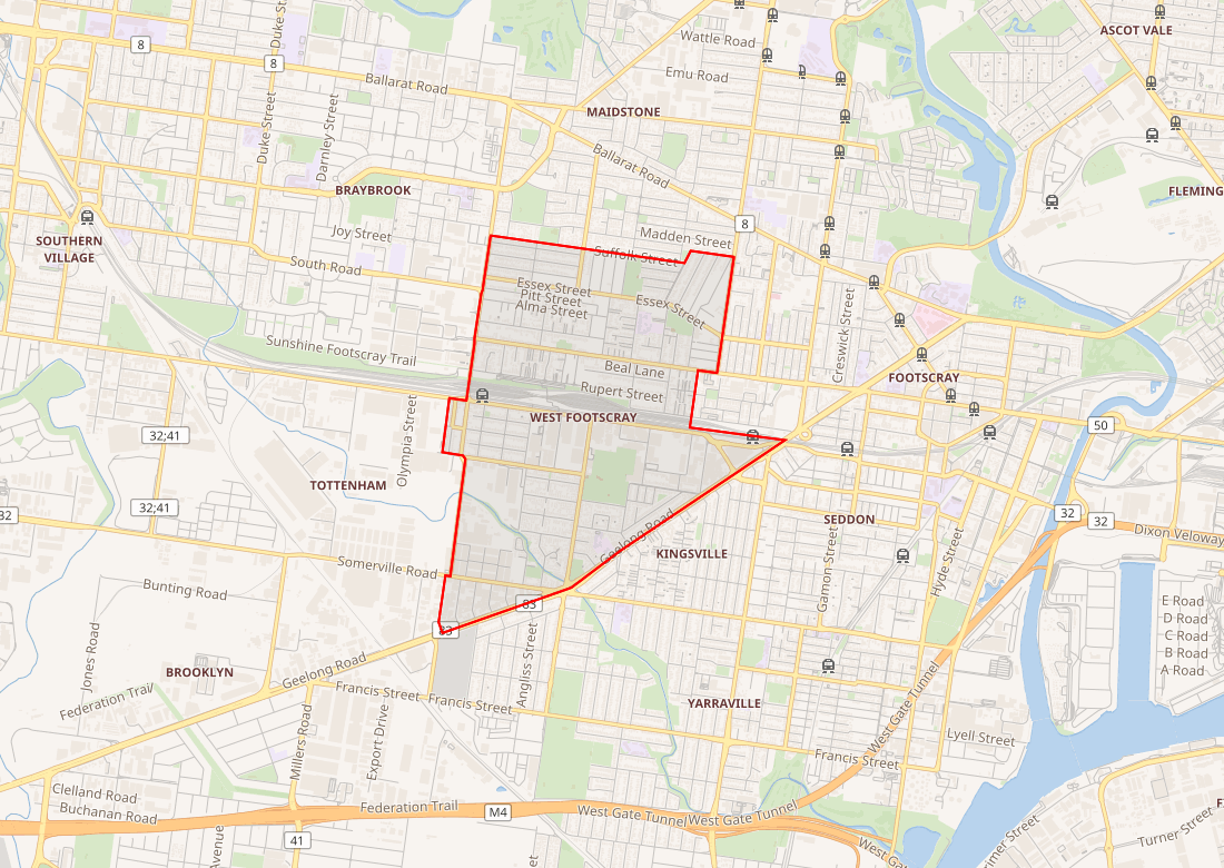
The suburb sits west of Footscray, in the City of Maribyrnong. The outline below is the OpenStreetMap locality. The census figures further down are for the Australian Bureau of Statistics suburb SAL22756, which is a different boundary dataset.
Transport and access
Stations: West Footscray Station
Lines: Sunbury Line
West Footscray station is on the Sunbury line.
Infrastructure projects
The named station works on the corridor from here to Albion are new stations at Tottenham and Albion, and extra platforms at Sunshine. Tracks past Albion, and a station at the airport, are later stages. The project page does not treat the stage investment as a budget for the whole line.
Projects: Melbourne Airport Rail
Planning and development
Amendment GC270 came into operation on 31 March 2026. In West Footscray it applies Schedule 2 to the Built Form Overlay over the activity-centre core around the station. The schedule’s maximum heights are 21, 27, and 34 metres, depending on the area on its map, and each maximum is discretionary. On large opportunity sites the schedule says development may exceed the height standard where impacts are managed and a public benefit is provided. The Department of Transport and Planning’s West Footscray page, updated on 2 October 2026, still describes parts of the core as up to 12 storeys. The metres in the scheme are the control. The longer account is what the new planning rules allow. The 2026 program explainer ranks this station as a stage 1 centre, and the account of the 60 centres is the list of centres that explainer names.
Population and housing
| People usually resident | 11,729 |
| Median age | 35 |
| Private dwellings | 5,369 |
| People per household | 2.4 |
| Median weekly household income | $1,989 |
These figures are for the suburb, not for the City of Maribyrnong. On the same 2021 release the Victorian median age was 38, and the Victorian average household was 2.5 people.
History and local context
The area was home to the Wurundjeri Woi Wurrung and Boonwurrung peoples of the Kulin Nation before European settlement. It was sold off as “Upper Footscray” from the 1850s, while Footscray itself grew around the punt across the Maribyrnong River. The railway through the area opened in 1859, but trains did not stop here until Tottenham station opened in 1891, and development stayed slow.
Basalt quarrying shaped the suburb in the 19th century; Melbourne Punch called the area “Stoneopolis”, and its bluestone went into the Melbourne Town Hall. The post office opened in 1914 and the first school in 1915. Frank Beaurepaire’s Olympic Tyre Company opened its first factory on Cross Street in 1934, and the site made tyres until 2001; the building is now apartments.
Recent verified changes
Amendment GC270 came into operation on 31 March 2026. The department’s West Footscray page, updated on 2 October 2026, still describes parts of the activity-centre core in storeys.
Practical questions
Which height limit applies near the station?
The control is the height in metres in the planning scheme, not the storey description on the department page. Schedule 2 sets maxima of 21, 27, and 34 metres. Each is discretionary, and the schedule map decides which one applies to a site. On a large opportunity site the schedule allows a proposal above the standard where impacts are managed and a public benefit is provided. That permission to apply is not an approval already granted.
Does the airport rail work add a train to the airport?
Not on the stage now under way. Stage 1 is the corridor from West Footscray to Albion. The line beyond Albion, including a station at the airport, is a later stage.
How does this suburb relate to Footscray?
It is a separate suburb, immediately to the west, in the same council. It has its own station, on the Sunbury line. Footscray station is in the next suburb.
Sources and related places
- Amendment GC270, Maribyrnong Planning Scheme, Department of Transport and Planning. In operation on 31 March 2026.
- Schedule 2 to Clause 43.06, Built Form Overlay, Maribyrnong Planning Scheme. Maximum heights of 21, 27, and 34 metres, each discretionary.
- West Footscray, Department of Transport and Planning. Page last updated 2 October 2026. Storey descriptions, including up to 12 storeys on a large opportunity site.
- 2021 Census QuickStats: West Footscray (SAL22756), Australian Bureau of Statistics. People, median age, dwellings, people per household, and median weekly household income. The Victorian median age on that page is 38, and the Victorian average household is 2.5 people.
- West Footscray, Victoria, Wikipedia. The area’s Traditional Owners, its sale as Upper Footscray, the 1859 railway and the 1891 stop, the basalt quarries, the post office and school, and the Olympic Tyre factory.
- Photograph: West Footscray aerial panorama, June 2025, BobTanGo, CC BY 4.0, via Wikimedia Commons.
- Map: OpenStreetMap contributors, via Wikimedia Maps, retrieved 27 October 2026. Locality outline, not the ABS suburb boundary and not a survey plan.